 |
|
The tidal frequency of the river allows for seven hours of ebb-flow and only five hours of flood, so most of the time the steep grey-brown banks of sedimentary ooze are clear to all. On some spring tides the murky river rises and falls at a rate of more than three feet every 15 minutes, and that gave the Pill pilots an interesting, when not exacting, challenge as they took charge of the navigation of vessels making towards or sailing from berths inside the City of Bristol. In order to understand the topography of the village it is best to look at its very name. The location of Pill is beside a creek. It is a creek that dominated the life of the village for its entire existence. Indeed the creek is why the village stands there at all. "Pill" literally means a creek or an inlet of a river or channel; or it means a small harbour, often tidal and occasionally used as a dock. The Oxford English Dictionary describes it as "A local name on both sides of the Bristol Channel, in Cornwall, etc., for a tidal creek on the coast, or a pool in a creek, etc.". Any map showing the navigable part of the river Avon, the mouth of the river Severn and the eastern portion of the Bristol Channel will show quite a number of creeks referred to as a "pill". But without exception they all have a proper name before the "pill". For instance, in the Severn there is Lydney Pill and Chepstow Pill, whilst in the Avon there is Broad Pill, Morgan's Pill and Chapel Pill, formerly known as St Katherine's Pill. And it is in the river Avon that we find the largest creek of all, variously called The Pill, The Creek, Crockerne Pill, Crockarn Pill, Crockham Pill, and so on. The very first map to show the hamlet of Pill is Saxton's map of "Somersetsen" (dated 1575, its original is extremely well preserved in the British Library), and it names the creek and hamlet as "Crockhampil". Speedes's map of Somerset, dated 1610, calls them both "Crockhampill". On the next two maps, chronologically speaking, we find the creek and surrounding area marked as just Pill. The "Division of Hundreds" map of 1805 once again brings in a prefix, this time as "Crockern Pill" and the "General Map of Somerset & Gloucester", also 1805, shows "Crockerne Pill". By 1828 J. Rutter's "Delineation of Somerset" and subsequent maps mark the hamlet again as plain Pill.
As for the Romans, they seem to have passed by the part of the Avon on which Pill lies. Their road from Severn to Bath, the Rua Julia, passed well to the north and east of Pill. But by the time of Henry VII mariners from Pill were well into their stride. It was in Henry's reign that one Giovanni Cabotto convinced the merchants of Bristol to fund a "voyage of discovery", and with letters patent from the King he set out. But that is another story. By the fifteenth century the mariners and boatmen of Pill were unrivalled on the river Avon. There was no Avonmouth; Shirehampton did not exist; Sea Mills wasn't there; and the Hotwells hadn't been invented. The entire eastern (Gloucestershire) bank of the river Avon, from its mouth to the walls of Bristol City, was undeveloped, though a rough tow path did exist along some of its length. One must also remember that the river was more than a mile longer in those days than it is now, with the Royal Edward Dock at Avonmouth built on the original river course. So it is safe to say that the mariners of the Crockarn Pill held total control of the river. The inhabitants of the City of Bristol were "citizens" born and bred inside a walled enclave. Mere "townies", they could never make it as men of the river. There were no lock gates to hold the water high and keep the ships afloat over the ebb. Indeed the tide in the river Avon at the "Key" probably allowed vessels to float only for very short periods over high water. For the greater part of the time ships nestled in the soft mud as if in dry dock. The datum of the river bed in the centre of Bristol was considerably higher that at the mouth. When a vessel had been fitted out and was ready to leave the City and proceed to sea, it would therefore have to leave the "Key" at or near high water. It would have to be pulled along from Bristol to the river mouth, either by oarsmen rowing in small boats, or by "hobblers", which in this instance means those employed to tow the vessel by ropes on land. This strenuous work was always carried out by men, and on occasion by women, from the village of Pill. Many references to them and to their lives and times are available in the "Hall Books" (minute books) of the Bristol Merchant Venturers. A complete set, now on microfilm, is available in the Bristol Central Library. As ships grew larger, so passage into the centre of the City of Bristol became more hazardous. Vessels were stranded, and some became a total loss. So the port moved downriver to Hungroad, which is the great bend of the Avon that lies between the Crockarn Pill and Saint Katherine's Pill, now Chapel Pill. The a chapel was for sailors to pray before a voyage for their safe return, and no doubt to give thanks if return they did.
These days, millions unwittingly speed past Pill. As you drive south on the M5 motorway across the Avon Bridge, to the right is the huge industrial complex that includes the modern Royal Portbury Dock. Down to the left, in stark contrast, are the green fields of the ecclesiastical parish of Pill. Both bits form part of the civil parish of Easton-in-Gordano, and both mean much for the lives of the modern-day pilots and other mariners who still make Pill their home. The writer is a retired Bristol Pilot, and a local historian The writer is a retired Bristol Pilot, and a local historian. |
 THE village of Pill in the county of Somerset lies on the western bank of the river Avon towards its confluence with the river Severn and the eastern most part of the upper Bristol Channel. It has a long maritime history and is known by many as "Pill-on-the -mud", the ancestral home of the Bristol Channel Pilots.
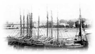 Is it because this particular "pill" has been so intensively worked whilst all the others remained relatively dormant, that its prefix, whatever it was, has disappeared? The difference between "Crockarn" and "Crockam" is relatively easy to explain, as the pen hand of a scribe in times past could easily make an "arn" appear as an "am", and the "e" and "a" are not easily distinguishable in some early writing. But why the name in the first place? Was it the "creek of the crocks"? After all, a large pottery was excavated at nearby Ham Green, and its pottery shards have been found all over the Bristol Channel area, including west Wales.
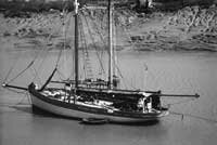 Many times the Bristol Merchants attempted to break the lock that Pill boatmen had on the river that led up to what then was England's second greatest port. They tried to appoint their own candidates to fill vacancies. Yet outsiders were always rejected by the men of Pill, and none ever succeeded in breaking the closed shop. And it was not until 1861 that other ports in the Bristol Channel succeeded in breaking the monopoly of the Pill pilots. Their influence on the Bristol pilotage remained undimmed. In 1863 there were 74 licensed Bristol Pilots, with 45 named boats. Each and every one worked from the creek at Pill, and each Pilot came from a Pill family. A list of everyone known to have been authorised to act as a Pilot in the Port of Bristol since licensing began is published in my book "The Bristol Pilots", which covers a period of nearly 500 years and includes dates, boat names and boat registration numbers. I'm afraid this book is now out of print and is available only through local public libraries.
 |